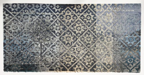
“Hinushi is a series of landscape photographs from ancestral homelands woven through colonial maps of the Mississippi River, Gulf of Mexico, and Choctaw allotment land. The blue allotment maps of McCurtain County, Oklahoma (1902, courtesy of the Choctaw Cultural Center) were created after the United States Indian Removal Act (1830). Each drawn parcel indicates allotted land for individual Choctaw Tribal members and includes their name, blood quantum, and age, serving as a government document and form of assimilation into the colonial structure of land ownership, further displacing cultural values and land connectivity. After removal from their ancestral land, Choctaws suffered a long walk to “Indian Territory” or what is now called Oklahoma. Woven together are maps from Oil News (1920, from my research at the British Library, London, England) woven through Broken Bow landscapes, where our family was relocated. Choctaw basket patterns from my Grandma Chillie’s basket of sun and stars are woven through these maps, joining the land with the colonial maps as an act of reclamation. The journaling and mapping are photographs of Lewis and Clark journals taken during my archive research at the St. Louis Historical Society. The Lewis and Clark Corps of Discovery Expedition (1804-1806) was funded by the United States government and initiated by Thomas Jefferson after the Louisiana Purchase (1803). These colonial forms of exploring, discovering, and mapping are constructed to manage land and people. The colonial mapping and government allotment structures represent established spaces. Weaving Chitimacha and Choctaw patterns through the maps reclaims space.
The trunks of Coastal Redwoods from California and Live Oak Trees from Avery Island, Louisiana, sit on top of the roots with maps from Lewis and Clark’s journals laid over the trunks and are woven together with a Chitimacha basket pattern. Louisiana maps merge with Oklahoma maps as the two weaving styles collide. My son, Archie, is discretely woven into some of the pieces as he stands in the Broken Bow landscape and is then woven into Tahoe, reflecting on connection after relocation. Maps and archives from the past woven into contemporary landscape photography close a gap of time. Similarly, placing a figure into a landscape can also blend time and represent Indigenous futurism by reclaiming space and re-implementing self into a land of ancestry that was otherwise taken from the ancestors. This process of weaving together past, present, and future broadens the visual experience to something that is felt and not seen, bringing spirituality into the works.” – Sarah Sense

